

Wind: 12mph NE
Humidity: 73%
Pressure: 30.04"Hg
UV index: 3
77°F
77°F
77°F
77°F
84°F / 75°F
82°F / 75°F
82°F / 75°F
82°F / 75°F
KAUAI 7-DAY FORECAST
RADAR | SATELLITE | HOURLY FORECAST | HIGH TEMPERATURE | CHANCE OF PRECIPITATION
Monday: Scattered showers before noon. Partly sunny, with a high near 85. Southeast wind 9 to 13 mph. Chance of precipitation is 40%. New precipitation amounts of less than a tenth of an inch possible.
Monday Night: Scattered showers, mainly after midnight. Mostly cloudy, with a low around 74. East northeast wind 11 to 14 mph, with gusts as high as 18 mph. Chance of precipitation is 30%.
Tuesday: Isolated showers before noon. Partly sunny, with a high near 85. Breezy, with an east wind around 15 mph, with gusts as high as 21 mph. Chance of precipitation is 20%.
Tuesday Night: Scattered showers, mainly after midnight. Mostly cloudy, with a low around 73. Breezy, with an east northeast wind 11 to 15 mph, with gusts as high as 21 mph. Chance of precipitation is 40%.
Wednesday: Scattered showers, mainly before noon. Partly sunny, with a high near 85. Breezy, with an east northeast wind 11 to 15 mph, with gusts as high as 21 mph. Chance of precipitation is 30%.
Wednesday Night: Scattered showers. Mostly cloudy, with a low around 74. Breezy, with an east northeast wind around 15 mph, with gusts as high as 21 mph. Chance of precipitation is 40%.
Thursday: Scattered showers, mainly before noon. Partly sunny, with a high near 84. Breezy, with an east northeast wind around 16 mph, with gusts as high as 22 mph. Chance of precipitation is 40%.
Thursday Night: Scattered showers. Mostly cloudy, with a low around 74. Breezy, with an east wind around 16 mph, with gusts as high as 22 mph. Chance of precipitation is 40%.
Independence Day: Scattered showers. Partly sunny, with a high near 85. Breezy, with an east wind around 17 mph, with gusts as high as 24 mph. Chance of precipitation is 40%.
Friday Night: Scattered showers. Mostly cloudy, with a low around 74. Breezy, with an east northeast wind 15 to 17 mph, with gusts as high as 24 mph. Chance of precipitation is 50%.
Saturday: Scattered showers. Partly sunny, with a high near 85. Breezy, with an east northeast wind 17 to 20 mph, with gusts as high as 28 mph. Chance of precipitation is 40%.
Saturday Night: Scattered showers. Mostly cloudy, with a low around 75. Breezy, with an east northeast wind 17 to 20 mph, with gusts as high as 28 mph. Chance of precipitation is 40%.
Sunday: Scattered showers. Partly sunny, with a high near 85. Windy, with an east wind 20 to 23 mph, with gusts as high as 32 mph. Chance of precipitation is 40%.
![]()
KAUAI SURF REPORT
Surf along south facing shores should see a small, long-period south swell slowly fill in through tonight, with surf peaking near or slightly above the summertime average late Monday through Tuesday. This swell will then gradually decline through the rest of the week. A smaller long-period south swell could move through toward the end of this week for a slight boost to south shore surf. Surf along east shores will gradually decline over the next several days due to the trade winds weakening. Surf along north facing shores will remain tiny throughout next week.
MONDAY
North: 0-2 ft am | 0-2 ft pm
West: 2-4 ft am | 3-5 ft pm
South: 3-5 ft am | 4-6 ft pm
East: 2-4 ft am | 2-4 ft pm
(Surf heights in feet from trough to crest. Surf heights can vary significantly from beach to beach.)
SOURCE: National Weather Service (Weather.gov)
![]()
RAIN GAGES (USGS)
- Kilohana Rain Gage Near Hanalei
- Mohihi Crossing Rain Gage Near Waimea
- Mt. Waialeale
- Waiahi
- Waiakoali Rain Gage Near Waimea
- Waialae Rain Gage Near Waimea
- Wailua Ditch Rain Gage Near Lihue
![]()
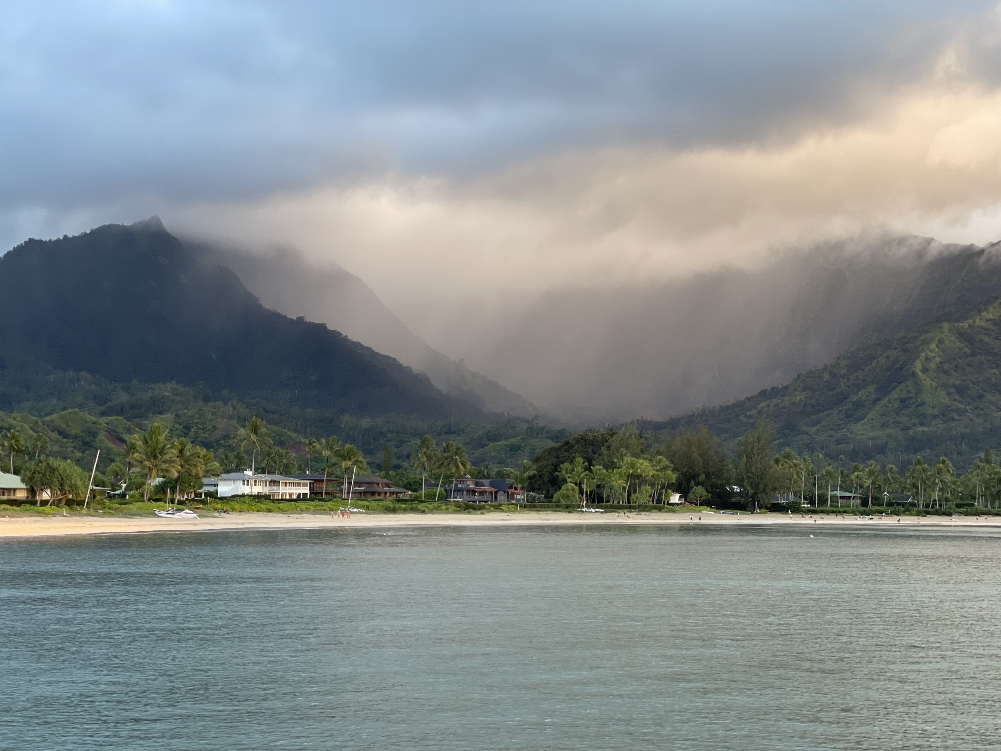
Kauai Weather Photo of the Day: Hanalei Rain Shower
Kauai Weather: Rain and Shine
Kauai, known as the Garden Isle, boasts a rich, tropical landscape that owes much of its lush beauty to its unique and ever-changing weather. Whether you’re a local resident, a frequent visitor, or planning your first trip, understanding Kauai’s weather patterns can help you make the most of your time on the island.
A Tale of Two Coasts
One of the most striking things about Kauai’s weather is how much it can vary across the island. The north and east sides – like Hanalei, Princeville, and Kilauea – tend to be wetter and cooler, thanks to the trade winds that blow in from the northeast. These regions are often blanketed in soft morning showers, followed by pockets of sunshine throughout the day.
In contrast, the south and west sides – Poipu, Waimea, and Kekaha – are generally drier and sunnier. This makes them popular destinations for beachgoers and sun-seekers, especially during the wetter winter months on the North Shore.
Year-Round Warmth
Kauai enjoys a mild, tropical climate year-round. Daytime temperatures typically range from the mid-70s to mid-80s Fahrenheit (24–29°C), with cooler temperatures at night, especially in the higher elevations like Kokee State Park. Humidity is a thing on Kauai, something many people notice as soon as they get off the plane. But trade winds help keep things comfortable, providing a natural breeze that’s especially welcome in the warmer months.
Rain: A Blessing in Disguise
Rain is an essential part of life on Kauai. It’s what keeps the waterfalls flowing, the taro fields healthy, and the mountains vibrant with green. But don’t let the rain scare you off. Showers tend to be brief and localized, and the sun returns soon after, sometimes accompanied by a brilliant rainbow arching over the landscape. Visitors will often check the weather reports in advance of their trips, only to be dismayed when every day shows a one hundred percent chance of precipitation. Yes, it will most likely rain somewhere on Kauai every day, but it’s rare for an entire day to be washed out unless there is a major storm system in the area.
When to Visit
While Kauai doesn’t have four traditional seasons, it does experience two main weather patterns:
- Wet Season (November to March): Expect more frequent rain showers, especially on the north and east sides of the island. Ocean conditions on the north and west shores can also be rougher, with large surf.
- Dry Season (April to October): Rainfall tends to decrease, and skies are generally clearer, particularly on the south and west shores. Ocean conditions become calmer on the North Shore, making it a great time for snorkeling and swimming.
Regional Differences
Kauai’s terrain creates a variety of microclimates across the island. Weather conditions can vary significantly depending on where you are:
- North Shore (Hanalei, Princeville): Receives the most rainfall. Expect a mix of sun and showers, often within the same hour.
- East Side (Kapaa, Wailua): Experiences regular trade winds and occasional showers. Generally warm and breezy.
- South Shore (Poipu, Koloa): Tends to be sunnier and drier, especially in winter.
- West Side (Waimea, Kekaha): The driest and hottest part of the island, with more arid conditions.
- High Country (Waimea Canyon and Kokee State Park): The Waimea Canyon area tends to be drier and sunnier, like the west side. As you drive up into the higher elevations at Kokee State Park, the weather can become more damp, misty and rainy. Bring a light jacket, especially in the winter months, in case of rain in this area as it can feel downright cold when mixed with the precipitation.
Tips for Navigating the Weather
- Check the radar: Apps like MyRadar can show real-time weather conditions to help you plan your day.
- Pack smart: Bring light rain gear, quick-dry clothing, and reef-safe sunscreen. A lightweight hoodie or jacket is great for higher elevations.
- Be flexible: If it’s raining on the North Shore, try heading to Poipu or points farther west instead. Kauai rewards those who adapt.
- If you have or rent a convertible vehicle, never leave the top down when you’re away from the vehicle, not even for five minutes. Rain on Kauai has a habit of striking out of nowhere.
In the End, It’s All Part of the Magic
The weather on Kauai isn’t something to avoid – it’s something to embrace. It’s what makes the valleys green, the skies dramatic, and the rainbows frequent. Whether you’re chasing the sun or savoring a rainy day nap, the Garden Isle has a way of making every forecast feel just right.